

BG
BG
BG
Avatar
Avatar
Avatar

360aktiv outdoor apps

Move beyond the map.

Purpose-built mobile apps for every route, trail, coastline, and climb.

Route360 turns every journey into a living route—built for people who would rather be outside.

Start with Route360
Download Icon
Download Icon
Outdoor landscape

The Black Box behind every 360aktiv instrument.

The Unbreakable Engine


  • Heartbeat Persistence: Automatic data backup every 30 seconds to prevent data loss.

  • Disaster Recovery: Automatic session restoration after app updates or device reboots.

  • “Steady-Mark” Fusion: Professional Kalman filtering for compass and altitude stability.

Expedition History


  • Black Box Database: Centralized storage of every past mission and GPX track.

  • Telemetry Replay: “Time-travel” slider to re-trace any trip with synchronized mapping.

  • Visual Profiles: Synchronized elevation and speed charts for post-trip analysis.

Global Calibration


  • Google Earth Anchor: High-precision altitude calibration using global terrain APIs.

  • Visual Settings: Dual-pane dashboard for real-time sensor calibration.

  • Geocoding Engine: Automatic City/Country identification from raw GPS data.

  • DMS Conversion: Professional coordinate formatting (Degrees, Minutes, Seconds).

Common Functions


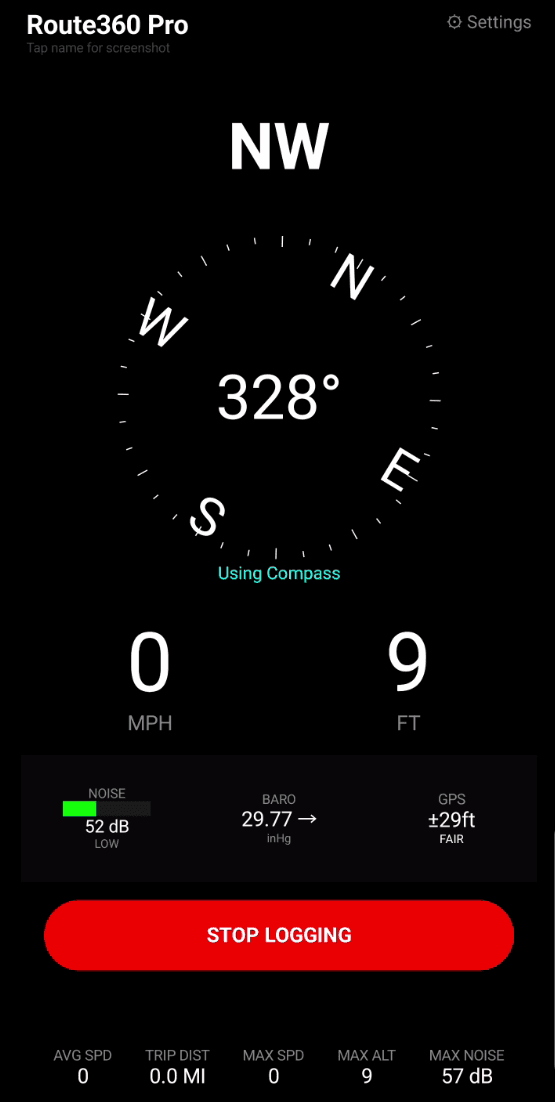
  • Tap app name for screen capture

  • Location sharing: Tap GPS quality to share your position with friends and family.

  • Icy-condition warnings: Get alerted when conditions may be unsafe.

  • Compass rose: Stay oriented with a clear heading display.

  • Elevation and speed: Keep key performance data in view.

  • Weather information: Read the conditions before and during your journey.

BG
Icon

From the field

Icon

From the field

Made for people who keep going.

Icon

“Route360 makes it easy to stay oriented when the day turns into something bigger than planned.”

Avatar
Rating Icon
Rating Icon
Rating Icon
Rating Icon
Rating Icon

Evan Carter

Trail Runner

Icon

“Route360 makes it easy to stay oriented when the day turns into something bigger than planned.”

Avatar
Rating Icon
Rating Icon
Rating Icon
Rating Icon
Rating Icon

Evan Carter

Trail Runner

Icon

“The offline route tools are exactly what I want before heading beyond coverage.”

Avatar
Rating Icon
Rating Icon
Rating Icon
Rating Icon
Rating Icon

Maya Lund

Weekend Explorer

Icon

“The offline route tools are exactly what I want before heading beyond coverage.”

Avatar
Rating Icon
Rating Icon
Rating Icon
Rating Icon
Rating Icon

Maya Lund

Weekend Explorer

Icon

“Sail360 puts the details I check most right where I need them—fast and clear.”

Avatar
Rating Icon
Rating Icon
Rating Icon
Rating Icon
Rating Icon

Nils Jensen

Coastal Sailor

Icon

“Sail360 puts the details I check most right where I need them—fast and clear.”

Avatar
Rating Icon
Rating Icon
Rating Icon
Rating Icon
Rating Icon

Nils Jensen

Coastal Sailor

Route360

PROFESSIONAL INSTRUMENT SUITE · DRIVING TELEMETRY

Move beyond the map with a professional-grade driving instrument suite built on Route360’s 10Hz Unbreakable Engine for fluid, zero-lag telemetry.

Professional Cockpit Instrumentation

  • 10Hz Unbreakable Engine: Processes sensor data 10 times per second for a smooth, responsive speedometer.

  • Aviation-Grade Altimeter: Three-hand vertical navigation with x100 and x1000 scales.

  • Dynamic Compass Rose: Course Over Ground tracking with Heading Lock capability.

  • Environmental Suite: Cabin noise, weather trends and atmospheric pressure at a glance.

Active Safety & Documentation

  • Safety Sentinels: Real-time alerts for erratic motion, swerving, icing and low-visibility fog.

  • Coffee Sentinel: Predictive fatigue monitoring that suggests timely breaks.

  • Smart Photolog: Pins drive photos to your route map automatically.

  • Black Box Replay: Interactive mission history with a telemetry slider and elevation charts.

  • Surveyor-Grade Accuracy: Kalman filtering and barometric fusion reduce GPS jitter.

Compare Route360 tiers

Get Route360 on Google Play
Route360 mobile app showing a map route
Hike360 icon

Hike360

TRAIL APP · ELEVATION AND WAYPOINTS

Find your line, track your elevation, and keep every waypoint close when the trail leaves the signal behind.

Navigation & Mapping

  • Steady-Mark Compass: Visual compass rose with sensor-fusion stabilization.

  • Topographic Mapping: Full-screen terrain maps with breadcrumb path rendering.

  • Ghost Marks: Tap-to-lock target heading bugs for off-trail navigation.

  • Handshake Loader: Industrial GPX importer for Strava and AllTrails tracks.

Telemetry & Safety

  • Climb HUD: Real-time Grade (%) and Elevation Gain/Loss tracking.

  • Pace Calculator: Live pace monitoring (Min/Mile or Min/KM).

  • Step Integration: Physical step counting and cadence (Steps/Min) recording.

  • SOS Sentinel: One-tap emergency siren and SMS location broadcasting.

  • Homing Indicator: Visual "Back to Start" arrow for safe returns.

Hike360 mobile app screenshot
Hike360 icon

Hike360

TRAIL APP · ELEVATION AND WAYPOINTS

Find your line, track your elevation, and keep every waypoint close when the trail leaves the signal behind.

Navigation & Mapping

  • Steady-Mark Compass: Visual compass rose with sensor-fusion stabilization.

  • Topographic Mapping: Full-screen terrain maps with breadcrumb path rendering.

  • Ghost Marks: Tap-to-lock target heading bugs for off-trail navigation.

  • Handshake Loader: Industrial GPX importer for Strava and AllTrails tracks.

Telemetry & Safety

  • Climb HUD: Real-time Grade (%) and Elevation Gain/Loss tracking.

  • Pace Calculator: Live pace monitoring (Min/Mile or Min/KM).

  • Step Integration: Physical step counting and cadence (Steps/Min) recording.

  • SOS Sentinel: One-tap emergency siren and SMS location broadcasting.

  • Homing Indicator: Visual "Back to Start" arrow for safe returns.

Hike360 mobile app screenshot
Sail360 icon

Sail360

MARINE APP · WIND, COURSE, AND CONDITIONS

Stay with the conditions, read the water, and keep your course clear from first light to a safe return.

Marine Performance

  • Nautical Dashboard: Speed in Knots (KTS) and Distance in Nautical Miles (NM).

  • VMG Calculator: Velocity Made Good relative to the wind.

  • Tactical Wind Lock: Manual wind direction override for racing tack analysis.

  • Heel Gauge: Real-time vessel list/heel angle monitoring.

Strategic Navigation

  • Course Over Ground (COG): Stabilized heading blending GPS and physical sensors.

  • Course History: Professional marine track logging with full telemetry replay.

Sail360 mobile app screenshot
Sail360 icon

Sail360

MARINE APP · WIND, COURSE, AND CONDITIONS

Stay with the conditions, read the water, and keep your course clear from first light to a safe return.

Marine Performance

  • Nautical Dashboard: Speed in Knots (KTS) and Distance in Nautical Miles (NM).

  • VMG Calculator: Velocity Made Good relative to the wind.

  • Tactical Wind Lock: Manual wind direction override for racing tack analysis.

  • Heel Gauge: Real-time vessel list/heel angle monitoring.

Strategic Navigation

  • Course Over Ground (COG): Stabilized heading blending GPS and physical sensors.

  • Course History: Professional marine track logging with full telemetry replay.

Sail360 mobile app screenshot
Biking360 icon

Biking360

CYCLING APP · RIDE DATA AND NAVIGATION

Ride farther with live route guidance, clear ride data, and a record of every climb, turn, and open road.

Ride HUD

  • XL Speedometer: Large-format, high-contrast speed display for glancing while riding.

  • Grade Monitor: Precision incline (%) tracking for mountain bike climbs.

  • Odometer: Total trip distance and elevation profile logging.

  • Map Toggle: Instant switch between the Map view and the Compass Rose.

Fitness Integration

  • Strava Handshake: One-tap mission export to standard GPX format.

  • Weather Watch: Real-time wind speed and direction alerts for headwind planning.

Biking360 mobile app screenshot
Biking360 icon

Biking360

CYCLING APP · RIDE DATA AND NAVIGATION

Ride farther with live route guidance, clear ride data, and a record of every climb, turn, and open road.

Ride HUD

  • XL Speedometer: Large-format, high-contrast speed display for glancing while riding.

  • Grade Monitor: Precision incline (%) tracking for mountain bike climbs.

  • Odometer: Total trip distance and elevation profile logging.

  • Map Toggle: Instant switch between the Map view and the Compass Rose.

Fitness Integration

  • Strava Handshake: One-tap mission export to standard GPX format.

  • Weather Watch: Real-time wind speed and direction alerts for headwind planning.

Biking360 mobile app screenshot
Fleet360 logo

FLEET360 · INDUSTRIAL FLEET INTEL

Fleet intelligence that goes beyond the map.

Fleet360 transforms standard mobile devices into forensic data-loggers, giving managers live mechanical intelligence and automated cloud synchronization across the entire fleet.

Fleet360 Go

A high-precision driver app with one-tap fleet joining, mechanical readouts from Bluetooth OBD, duty odometer tracking, and automatic forensic GPX manifests at shift end.

Fleet360 Pro

A tactical manager dashboard for live command mapping, vehicle health scanning, diagnostic fault visibility, and tamper detection that protects the integrity of every mission.

Universal Cloud Sync

Send fleet data to OneDrive, Google Drive, Dropbox, or an internal server through Universal Webhooks—so telemetry lands exactly where your operations team needs it.